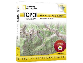
TOPO! New York / New Jersey
Item Number: 5059
Time Left: CLOSED
Description
TOPO! State Series – National Geographic’s best selling, top-of-the-line, digital map software is the easiest way to create & print detailed maps. Each program includes 1,000’s of the highest quality USGS topographic maps, optimized for printing and ease of use.
TOPO! gives you five levels of map detail, from two National Geographic Atlas maps to a USGS 1:24,000 scale (7.5’) seamless topographic map – the most detailed outdoor recreation maps available.
Maps include:
• (2) National Geographic Atlas Maps
• USGS 500,000 Scale Maps – Highlights public lands
• USGS 100,000 Scale Topographic Maps – Mid-Scale topos perfect for long trips
• USGS 24,000 Scale Topographic Maps – The most detailed terrain maps available
With TOPO!’s dynamic search features, you can quickly find your area of interest. Or simply browse the map to locate your desired destination.
TOPO! maps are full color, high resolution scans of authentic USGS topographic maps, providing the best image quality available. All maps are seamless, and easily printed from your home printer. Paired with National Geographic AdventurePaper, our waterproof, tear-resistant material, your maps become trail-tough.
TOPO! is the easiest way to tell your GPS where to go. Simply trace your route and upload to your receiver. Use in reverse to create detailed trail maps from your adventures.
Special Instructions
Item will ship directly from donor to winning bidder.