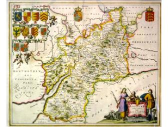
Antique Map of Gloustershire by Blaeu
Item Number: 187
Time Left: CLOSED
Value: $1,000
Online Close: Sep 29, 2011 8:00 PM EDT
Bid History: 0 bids
Description
An Antique Map of Gloustershire published by the Blaeu family. The map is matted and framed and has been conserved by the Williamstown Conservation Center. The finest Dutch map publishers were the Blaeu family, and they hold the title of mapmakers supreme for any period of cartographical history." (R. Baynton-Williams, "Investing in Maps"). Willem Janszoon Blaeu (1571-1638) was the founder of the Blaeu publishing house. In 1634 he commenced publication of the "Theatrum Orbis Terrarum" or "Novus Atlas" and on his death he was succeeded by his son Johannes (1596-1673). Johannes continuously enlarged and updated the "Theatrum" up to 1658, including the addition of a separate volume devoted to England and Wales. Blaeu maps are renowned for the consummate care and attention apparent in every stage of production - using only the best paper with finely engraved plates and a high standard of printing. The county maps have decorative title cartouches and often depict the coats of arms of those families with important county links.