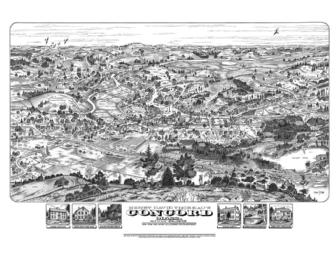
Thoreau's Concord Map Print
Item Number: 164
Time Left: CLOSED
Description
An historically accurate illustrated view of Concord as it appeared in Thoreau's time. Created in 2006 with the aid of a Thoreau Society Fellowship, the art was illustrated in the style of the historic 19th-century bird's-eye-view maps (none having been been produced during that period). The print measures 20" x 30", is printed on a heavy off-white stock, and is accompanied with a fact sheet noting the specifics of the image. Shipped rolled anywhere in the continental US.
Donated by
John Roman