NFCT 13 Map Set
Item Number: 115
Time Left: CLOSED
Description
The Northern Forest Canoe Trail links the waterways of New York, Vermont, Quebec, New Hampshire and Maine.
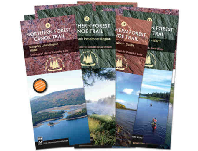
The route is divided into 13 sections, and each section has its own map with both route and interpretive information. The waterproof, tear-resistant maps include boat access, campsites, campgrounds, dams, portages, rapids, and waterfalls, as well as local contact information, permit guidelines and fascinating information about local history, wildlife, geology and more.
- Map 1: ADIRONDACK NORTH COUNTRY (West), NY, Fulton Chain of Lakes to Long Lake
- Map 2: ADIRONDACK NORTH COUNTRY (Central), NY, Long Lake to Saranac River
- Map 3: ADIRONDACK NORTH COUNTRY (East), NY, Saranac River to Lake Champlain
- Map 4: ISLANDS AND FARMS REGION, VT, Lake Champlain and Missisquoi River
- Map 5: UPPER MISSISQUOI VALLEY, VT/QC, Missisquoi River to Lake Memphremagog
- Map 6: NORTHEAST KINGDOM, QC/VT, Lake Memphremagog to Connecticut River
- Map 7: GREAT NORTH WOODS, NH, Connecticut River to Umbagog Lake
- Map 8: RANGELEY LAKES REGION, ME, Umbagog Lake to Rangeley Lake
- Map 9: FLAGSTAFF REGION, ME, Rangeley Lake to Spencer Stream
- Map 10: GREATER JACKMAN REGION, ME, Spencer Stream to Moosehead Lake
- Map 11: MOOSEHEAD/PENOBSCOT REGION, ME, Moosehead Lake to Umbazooksus Stream
- Map 12: ALLAGASH REGION (South), ME, Umbazooksus Stream to Umsaskis Lake
- Map 13: ALLAGASH REGION (North), ME, Umsaskis Lake to St. John River
Details per map:
• Scale: 1:1,000,000 (1″ = 1.6 miles)
• Contour interval = 20m/60ft
• Folded size (4″ x 9.25″)
• Unfolded size (18.5″ x 24″)
Special Instructions
Shipping: Maps ship directly from NFCT office
Donated by
Northern Forest Canoe Trail