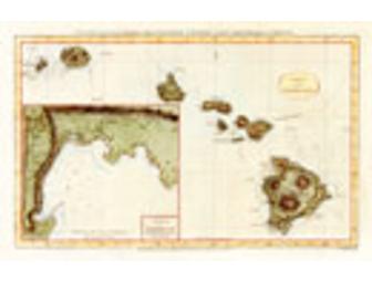
Hogg Map of Hawaii - "Chart of the Sandwich Isles"
Item Number: ART2
Time Left: CLOSED
Value: $199
Online Close: Dec 8, 2004 12:59 AM EST
Bid History: 0 bids
Description
Published by Alexander Hogg 1784-86
Captain James Cook created this historically important reproduction of the first charting of the Hawaiian Islands on his third and final Pacific voyage. Cook was assisted in his efforts by William Bligh, and the map was originally published in Anderson's Voyages of Captain Cook by Alexander Hogg in 1784-86.
It shows the path of the Resolution and the Discovery that tracks Cook's movements following his first visit to the Sandwich Islands in January 1778. The inset depicts Kealakekua Bay where the great navigator met his untimely demise on February 14, 1779.
Special Instructions
Giclee reproduction printed on premium canvas, matted, and framed. Printsellers' printer produces an apparent resolution of 1800 dots per inch, while spraying over 1 million droplets per second onto the chosen substrate. There are no screens used in this method of reproduction; therefore there is a smoother look to the final print. The precision of the printing, along with the depth of color range, captures the subtleties and nuances of an original image, whether it was created from watercolors, oils or acrylic.