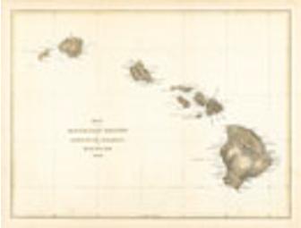
Wilkes Map of Hawaii - "Map Of The Hawaiian Group Or Sandwich Islands.."
Item Number: ART4
Time Left: CLOSED
Description
Giclee on Canvas, matted and framed. Size: 16x23. Published by Charles Wilkes 1841.
Special Instructions
The U.S. Ex. Ex. originally published this superior facsimile of the hand colored antique Map of the Hawaiian Group or Sandwich Islands in 1841. It clearly depicts the islands' regions, significant population centers and the location of its volcanoes, as they existed near the middle of the nineteenth century.
This map was first published during the reign of King Kamehameha III (1824-1854). In the early portion of his reign, royal matters were often interrupted by the belligerent conduct of foreign officers. These incidents eventually led to the recognition of the Islands' independence by the governments of Great Britain, France and the United States by 1844.