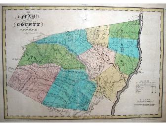
1829 Map of Greene County, N.Y.
Item Number: 132
Time Left: CLOSED
Value: $300
Online Close: Nov 6, 2009 5:00 PM EST
Bid History: 0 bids - Item Sold!
Description
An ORIGINAL copperplate-engraved map of Greene County from the first atlas of the State of New York by David H. Burr. Showing stage roads, flouring mills, factories, forges, saw mills, churches, early tracts & land patents, and a few landowners' names. Very accurate for it's time! Handcolored by township. One repaired tear, otherwise very nice condition. Ready to frame.
This is a Live Event Item.
Donated by
Jan Sosnowitz/John Tompkins